Tropical Storm Chantal to make landfall over South Carolina on July 6
Tropical Storm Chantal formed as the third named storm of the 2025 Atlantic hurricane season on July 5, 2025. It is forecast to make landfall over South Carolina on the morning of July 6, which would make it the first storm of the season to make landfall over the U.S.
Tropical Storm Chantal formed at approximately 12:00 UTC (08:00 EDT) on July 5. At the time of formation, it was located about 241 km (150 miles) south-southeast of Charleston, South Carolina, and 386 km (240 miles) south-southwest of Wilmington, North Carolina.
As of 15:00 UTC (11:00 EDT), the storm was located approximately 217 km (135 miles) south-southeast of Charleston, South Carolina, and 571 km (355 miles) south-southwest of Wilmington, North Carolina.
Chantal had maximum sustained winds of up to 64 km/h (40 mph) and was moving northward at 2 km/h (1 mph). Its estimated minimum central pressure was 1 007 hPa. Tropical-storm-force winds extended outward up to 145 km (90 miles), primarily east of the center.
A Tropical Storm Warning is in effect from South Santee River, South Carolina, to Surf City, North Carolina. A Tropical Storm Watch is in effect from Edisto Beach to South Santee River, South Carolina.
Chantal is expected to produce heavy rainfall across parts of the coastal plain of the Carolinas through July 6. Storm total rainfall of 51–102 mm (2–4 inches), with localized totals of up to 152 mm (6 inches), may trigger flash flooding in the warning areas.
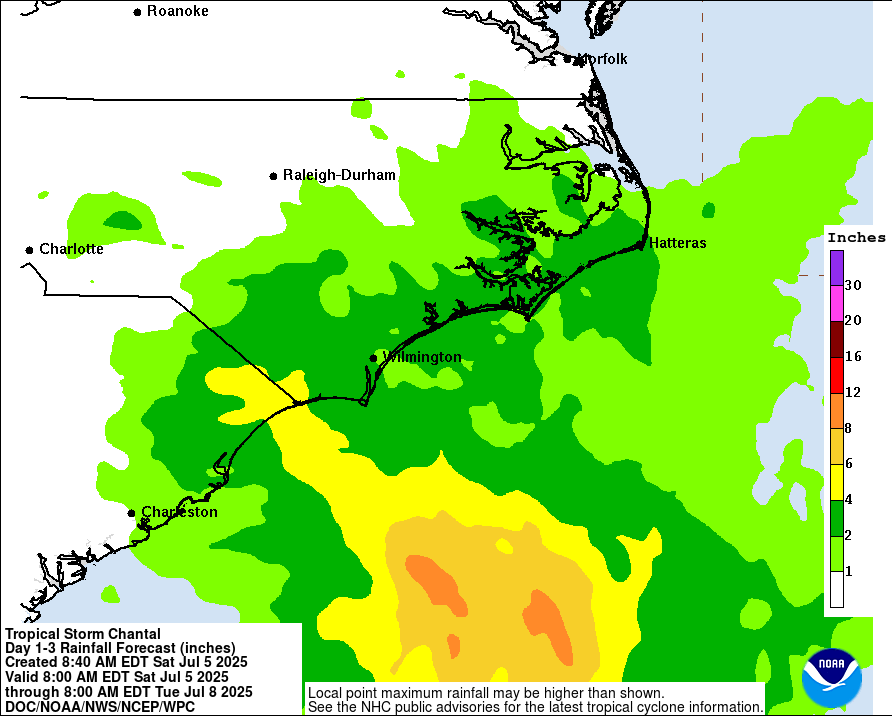
Isolated tornadoes are possible through the night of July 5 into July 6 along the coast of eastern South Carolina and much of North Carolina.
The storm is expected to bring dangerous surf and rip currents along the coast from northeastern Florida to the Mid-Atlantic states over the next couple of days.
Chantal is a slow-moving storm that has barely progressed on July 5 while heading northward at 2 km/h (1 mph). It is expected to shift north-northwest soon, steered by a low-pressure system over the Gulf and a ridge over the mid-Atlantic. The interaction between these features is forecast to drive Chantal inland, with landfall expected in South Carolina on the morning of July 6.
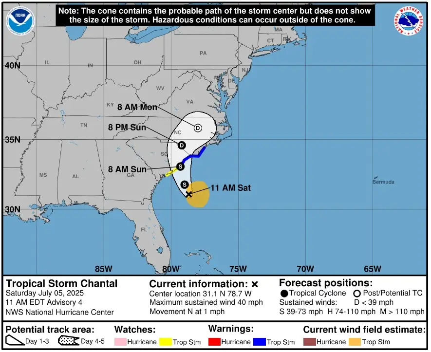
Center reformations are possible after landfall due to interaction with uneven terrain, which could result in erratic motion. The storm is expected to turn northeast as it moves along the western edge of the ridge.
Further strengthening is likely over warm waters and in an environment with lower wind shear. After landfall, the storm is expected to weaken steadily and dissipate within 48–60 hours. Chantal is expected to remain asymmetric, with the strongest winds on the right side of the landfall location.

Rishav is a skilled researcher specializing in extreme and severe weather reporting. He combines exceptional research capabilities with scientific precision to deliver clear, data-driven articles. Known for uncovering critical information, Rishav ensures his work is accurate, insightful, and impactful. His passion for both science and literature fuels his dedication to producing high-quality news articles. You can reach him at rishav(at)watchers(.)news.
Commenting rules and guidelines
We value the thoughts and opinions of our readers and welcome healthy discussions on our website. In order to maintain a respectful and positive community, we ask that all commenters follow these rules.