Severe thunderstorms forecast for northern Italy, Slovenia, Croatia, Hungary, Slovakia, Poland and Ukraine
Severe thunderstorms, accompanied by heavy rainfall, large hail, and damaging wind gusts, are forecast to affect northern Italy, southern Slovenia, western Croatia, northeastern Hungary, eastern Slovakia, western Ukraine, and eastern Poland on July 7 and 8, 2025. Widespread weather alerts have been issued by national agencies, with impacts expected in both urban and rural regions.
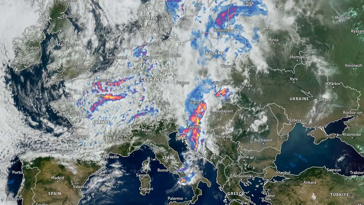
Image credit: EUMETSAT/Meteosat, Zoom Earth, The Watchers. Acquired at 09:40 UTC on July 7, 2025
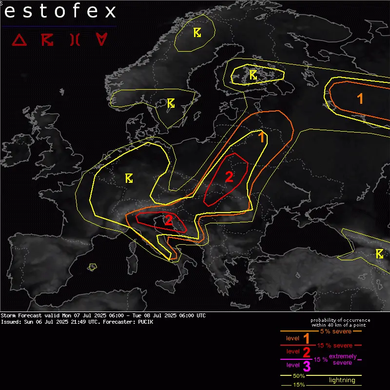
The European Storm Forecast Experiment (ESTOFEX) has issued a Level 2 risk for severe convective storms across northern Italy, southern Slovenia, western Croatia, northeastern Hungary, eastern Slovakia, western Ukraine, and eastern Poland from July 7 to 8.
According to ESTOFEX forecaster Pucik, the main threats are severe wind gusts, large hail, and locally heavy rainfall, particularly during the evening and night hours. National meteorological agencies in the affected countries have confirmed the potential for severe storms, issuing widespread warnings for damaging weather phenomena.
In northern Italy, Friuli-Venezia Giulia, Lombardia, and Veneto regions are under moderate (orange) alerts for thunderstorms, heavy rain, and hail on July 7. Yellow alerts are in effect for Emilia-Romagna, Liguria, Piemonte, and Trentino-Alto Adige. Temperatures will drop sharply, ending the ongoing heatwave, with strong convective development expected from late afternoon and evening hours, especially after 18:00 UTC.
Forecast models indicate two rounds of storms for northern Italy. The first round will occur during the morning, producing elevated storms with heavy rainfall and isolated large hail, mainly in the eastern risk zone. A weakening trend is expected by noon, followed by renewed storm development in the evening as pressure falls ahead of an approaching short-wave trough.
The most intense storms are forecast near the Adriatic Sea, posing a risk for very large hail and wind gusts exceeding 90 km/h (56 mph). Flooding may occur in low-lying or urban areas, particularly along rivers and hilly terrain.
In southern Slovenia and western Croatia, the Slovenian Environment Agency and Croatian Meteorological and Hydrological Service have issued yellow and orange alerts for severe weather, including large hail, wind gusts, and heavy rain. Warnings are in effect for Zagreb, Karlovac, Rijeka, and Osijek regions in Croatia, with gusts forecast to reach 65–85 km/h (40–53 mph) and rainfall locally exceeding 40–50 mm (1.6–2 inches). The strongest storm activity is expected after 18:00 UTC in Slovenia and after 21:00 UTC (23:00 local time) in Croatia, continuing into the night.
Two storm rounds are forecast for this region, a morning wave with heavy rain and a more severe evening wave as supercells and organized linear systems move east from Italy.
Higher values of CAPE (Convective Available Potential Energy), which indicates the potential for strong updrafts in thunderstorms, combined with strong low-level wind shear, will support the development of severe wind gusts, large hail, and possibly tornadoes. However, forecast models suggest the lower atmosphere may remain stable overnight.
In central Italy, forecasts indicate the persistence of overnight thunderstorm activity into the morning of July 7, supported by moderate CAPE and vertical wind shear. Another, more uncertain, round of storms is possible towards the morning of July 8, depending on the evolution of mid-tropospheric dryness.
In Hungary, Slovakia, Poland, Ukraine, and Romania, scattered thunderstorms are forecast during the morning, escalating to severe storms in the evening, especially in northeastern Hungary and eastern Slovakia. Gusts of 60–90 km/h (37 to 56 mph), hail over 2 cm (0.8 inches) in diameter, and rainfall exceeding 30 mm (1.2 inches) are forecast. Bow echoes and rapid upscale growth of storms are possible, with wind gusts as the primary threat.
Isolated severe storms may also develop in the warm sector over Ukraine and Romania, particularly near the Carpathians, with severe wind gusts and isolated large hail.
Eastward, forecast confidence decreases, but a deepening low-pressure system moving from Poland to Estonia will generate a strongly sheared environment in the eastern Baltic states, Belarus, and northwestern Russia. Storm initiation and CAPE remain questionable; however, isolated high-based storms may form, capable of severe wind gusts and, if adequate CAPE develops, possible tornadoes. Central-northern Russia will experience scattered to widespread storms.
National agencies advise preparedness for urban and flash flooding, especially in northern Italy, Slovenia, and Croatia. Disrupted transport, fallen trees, and infrastructure damage due to strong wind gusts are possible. Power outages may occur in affected regions, and marine hazards for small craft in the Adriatic due to gusty southwest winds (“jugo”) are expected. Localized hail damage to crops, vehicles, and property is likely, with public warnings in effect until at least July 8, 06:00 UTC.
References:
1 Storm Forecast – ESTOFEX – July 6, 2025

Reet is a science journalist and researcher with a keen focus on extreme weather, space phenomena, and climate-related issues. With a strong foundation in astronomy and a history of environmental activism, she approaches every story with a sharp scientific lens and a deep sense of purpose. Driven by a lifelong love for writing, and a curiosity about the universe, Reet brings urgency and insight to some of the most important scientific developments of our time.
Commenting rules and guidelines
We value the thoughts and opinions of our readers and welcome healthy discussions on our website. In order to maintain a respectful and positive community, we ask that all commenters follow these rules.